Dream Island


From Treasures, the inflight magazine of Asian Spirit

When I was young I dreamt of an island where swaying coconut trees tower against bright blue sky, where the surrounding water is emerald green and where white sandy beaches glimmer in the sun. For years this vision became my definition of the “perfect” island.

Eighteen years ago I bravely ventured into frontier territory, the Palaui Island Protected Landscape and Seascape and discovered a paradise that has all the elements I dreamt of and much more. It turned out to be an island dotted with coralline beaches, tall forest trees, seagrass meadows, mangroves, cliffs, tidal pools, springs, waterfalls, rock formations, islets and even a centuries-old Spanish lighthouse.

Being involved in the crafting of a community-based sustainable tourism project for Palaui Island, I have to travel to Cagayan almost every month. The project aims to ensure that all its natural and cultural heritage will remain for many generations. This is a very fitting goal for an island that has remained well preserved and this is partly due to the inclusion of the municipality of Sta. Ana into the 54,000 hectare, Cagayan Special Economic Zone and Freeport. The area which is being developed and managed by the Cagayan Economic Zone Authority (CEZA) also covers three other islands of the municipality of Aparri, namely Fuga, Mabbag and Barit. CEZA recognizes the great potential for tourism development and the benefits it could bring. Palaui Island, because of its pristine condition and many attributes, has been identified as a priority site and thus in March 2006 the Community-based Sustainable Tourism project was launched.

By land it normally takes ten hours from Manila to Tuguegarao and from there it is another 2 ½ hours to the town of Sta. Ana, the jump off point for Palaui Island. This year, Asian Spirit started having chartered flights twice a week from Manila to Macau via Tuguegarao City and flying drastically cuts down the travelling time. I had great anticipation for a trip back to the island as I fastened my seatbelt on board tha aircraft. The flight was brisk and only took 45 minutes.

From the San Vicente fish port I took a boat to visit an island unlike any other. Called Palami in old Spanish documents, the island is an emerging destination for outdoor adventure sports and most of it is frontier territory. It is located in the municipality of Sta. Ana, along the periphery of one of the most treacherous body of water in the Philippines, the Babuyan Channel.


Nature’s wild creation

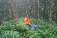
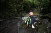
I have traveled to many remote locations in the country. I can endure the inconveniences of getting to far-flung places because I extremely enjoy experiencing the rawness of nature. It is almost always worth the time and effort. One important lesson I learned is that the more inaccessible a place is the more preserved it is. Palaui Island however has defied this rule. It is very accessible and yet it has well preserved terrestrial and marine ecosystems in place.

The protected area spans 7,415.48 hectares and includes primary and secondary forests, mangroves, caves, grassland, coral reefs, inter-tidal zones, seagrass meadows, geologic formations, small islets and a community of a little over 500 people. Forest cover is nearly 80 percent of the land area. Its forests serve as habitat for many threatened and near-threatened species of wildlife including the dwarf king fisher, rufous paradise flycatcher, serpent eagle and the tarictic hornbill. Resource inventories conducted by Conservation International and the University of the Philippines Institute of Biology show that the biodiversity of flora is very high, considering the size of the island.

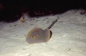
The island's seascapes exudes breathtaking sceneries. The submarine cliffs, shallow coral gardens, caverns, crevices and canyons provide niches for a wide variety of marine life. From the tiny nudibranch to turtles and whales, the domain beneath the surface of the water is also teeming with life. An underwater survey conducted in 2005 showed potential for recreational diving, underwater photography and even for research. Divers who conducted the survey were amazed at the variety of marine species. Some even claim to have seen species of marine sea slugs and snails that they have never seen anywhere else.

Tourism that protects

Being a protected area Palaui Island needs to be preserved. The law alone will not ensure that it will remain as it is for many years. Hence, island dwellers need to be capacitated to use the resources wisely and to engage in livelihood that are non-extractive. The potential of Palaui for environmental education and nature tourism is very clear. The community recognizes this and they have committed themselves to be stewards of this precious island. They have organized themselves into a group called Palaui Environmental Protectors Association (PEPA). CEZA had been providing technical assistance through training and enterprise development in order to increase their capability to improve their lives.

Tourism consultant Louie Mencias says that community involvement and capacity building are essential towards making tourism and nature conservation work, not just for Palaui but for other protected areas of the country.

“CEZA plans to build an ecolodge on the island that will comply with international standards. The community will be a partner in this initiative,” adds Mencias.

Bantay Kalikasan is a small group of volunteers that monitors and reports to authorities possible illegal activities on and around the island. The members double up as guides who ensure that visitors follow protected area protocols, deepen their understanding of nature, ecology, culture and history through indigenous knowledge interpretation, and have meaningful experiences as they hike the trails or cruise around the island.


Lighthouse restoration

On top of a hill 92.75 meters high, is the preserved centuries-old lighthouse of Palaui Island. It will soon be declared by the National Museum as an important cultural property. Designed by Engr. Magin Pers y Pers, construction started in 1887 but it was not completed until Dec. 30, 1892. The ravaging of time and of the natural elements has taken its toll and the lighthouse is in need of rehabilitation. With this concern, CEZA has established a partnership with the Department of Transportation and Communications, National Museum, National Historical Institute, National Commission on Culture and Arts and the municipality of Sta. Ana and the provincial government of Cagayan in order to take the necessary steps to save this built heritage. The Faro de Cabo Engaño is the northern-most Spanish lighthouse in the country and is in fact featured in the book “Spanish Lighthouses of the Philippine” by Manuel Noche.

“It is part of the Filipino heritage and we need to save it so that other people and future generations will appreciate its history,” says Sec. Jose Mari B. Ponce, CEZA Administrator and CEO.

In order to promote the island, CEZA has been organizing its yearly summer Aquathlon where top triathletes in the country compete.


As the island is being positioned as a place for authentic learning, visitors will soon be treated to an inspiring and highly educational experience that will promote responsible travel. Indeed heritage and biodiversity conservation , as well as sustainable tourism are important initiatives that will be integrated in the General Management Plan of Palaui Island. This only highlights the need to protect not only biodiversity, but also culture and history through sustainable tourism. This approach will certainly ensure that Palaui becomes a destination that will last for many generations.

Capuleños plan for tourism


Another Milestone for Bluewater was reached when stakeholders from the island of Capul participated in crafting the Capul Island Sustainable Tourism Development Plan. The planning process utilized a participatory approach. The seminar/workshop was attended by Barangay Captains and their officers, resort owners, teachers, LGU staff, youth and representatives from other sectoral groups.


The three-day workshop was an overwhelming success. The workshop provided an opportunity for the participants to learn contemporary concepts and strategies on tourism development for small islands. Throughout the entire process facilitators introduced planning tools that made them work together in assessing tourism resources, discussing issues and concerns, and assessing their strengths, weaknessess, opportunities and threats (SWOT). They also conducted a stakeholder analysis that made them realize that an understanding of the roles of each sector in the industry is the key towards establishing a strong Partnership.

Based on the evaluation of the participants, Capul seem to be a generally safe place to be. History is the most compelling or distinct feature of the island. Any tourism product development initiative should capitalize on this unique attribute. The lighthouse, the church and other historical landmarks show the greatest drawing power. Although the lighthouse has the potential to motivate travelers to come to the island, the road needs to be improved. The quality and quantity of amenities and facilities that will address the needs of tourists will have to be increased and standards elevated.


The culture and language will enhance visitor experience and should be integrated in the overall theme of the tour packages for Capul. The Capul Island Sustainable Tourism Plan highlights three major components - product development, social preparation and promotions and marketing. Participants agree that a balanced approach to tourism development is the best way to preserve history, culture and the natural environemtent of the island while optimizing economic bendfit.


Capul is also endowed with natural attractions. Beto cave in Barangay Sawang is a frequently visited site. Although workshop participants agree that it may need rehabilitation due to the numerous grafitti that had been placed by irresponsbile visitors that decided to immortalize themselves. All around the island are coves and white sand beaches that are washed by the currents of the San Berbardino. The flushing of the water creates emerald green waters that is home to a myriad of marine life forms. Selected sites can be quite excellent for snorkeling but may not be safe at certain times of the day due to the swift current.

UP Geography classes discover Baler, Aurora


Most people I ask about Aurora province, often react in the same classic way. They would say,"Aurora in Quezon?". The confucion results from the fact that Aurora used to be a sub province of Quezon. It became independent in Feb 19,1979. Hence, the province recently celebrated its 28th Foundation Day. Two Geography classes of the University of the Philippines conducted their field trip in Baler, the capital of Aurora. Except for three of the 37 students, all of them visited the Pacific side of the country for the first time. They were led by Geogaphy instructors Iona Lacson and Pryor Placino. Bluewater facilitated their trip and introduced them to the concept of outdoor education and environmental investigation. The former is about appreciation of land forms and their "story".


Through nature interpretation the participants were able to validate learnings derived from the classroom setting and discovered that various landforms are constantly under serious threat due to anthroppogenic activities. Environmental investigation exercises made the students look at the natural world from a different perspective. They were asked to be sensitive to "indicators" that provide clues to the current state of the environment of the place, the beliefs and values of the people using the resources, existing conflicts in resource use and the threats that the natural occurences pose on communities.


A trip to the PAGASA Weather Station situated on top of a hill overlooking Baler Bay and Dikasalarin proved to be a real workout for some but also educational. Thanks to Mr. Arthur Querijero and the other staff of PAGASA, the students learned how typhoons are tracked and detected. They also discovered that the white dome is actually a cover to protect the radar dish. PAGASA uses other instruments to measure wind speed, direction and barometric pressure.


Another highlight of the trip was a hike through varied terrains from a place near ASCOT (Aurora State College) all the way to the hanging bridge. Crossing the long bridge was quite exciting and even life altering to some who had the great opportunity to finally face their greatest fear. Congratulations Tiffany for facing your fear and doing it anyway. Way to go! For those who were able to sign up for some surfing lessons from the excellent local surfers of Baler, don't give up. Being able to kneel on the board is already quite an accomplishment,specially for first timers. The fact remains that you have conquered the surf of Baler, a major destination for seasoned surfers. This is a good enough reason to come back for more.


AMCO Beach Resort and Kamp Digisit, owned by Aida Miemban and August Miemban hosted this trip. The sumptuous meals, fresh buko, grilled fish, home-made suman,puto and rice cakes, as well as the pako (fern) salad made all of participants gain a pound of two. Thanks to your hospitality and care. Educational field trips and team building will be the main focus of Kamp Digisit in its future development scheme. Whether people travel for relaxation, for seminars and workshops or field trips, they are all tourists. Learning about the environment, the history of the place and its culture is part of the experience. Developing awareness on the fragility of nature and culture is a major objective of responsible tourism.

This field trip is part of the "Wildlife in the Classroom" program. This philosophy in outdoor education promotes Authentic Learning, a process of deep assimilation of life skills and values that makes a person a more responsible and productive member of the global community. For more information about this concept, visit www.wildclassroom.blogspot.com. If you are interested in letting us help you design a highy educational and life enhancing experience for your group, send us an email at wildexpeditions@yahoo.com.

Terra Incognita: Palaui


From Jetset magazine, January/February 2007

Six, four and two are the numbers to remember for Palaui Island. It stands for 642 , the distance of Manila to San Vicente, the last barangay in the northeastern portion of the island of Luzon. The numbers may be seen at the last km. marker near the fishport, which is the jump-off point to Palaui Island. It is fast becoming a tourist attraction in itself as visitors stop to have their pictures taken as proof that they have reached the tip of Luzon. They also stand for Six For Two, a special package designed for tourists who wish to know first hand what the island is all about. “Six activities for two days” provide a life changing experience as they explore the terrestrial and marine ecosystems, and learn about the history of the Century-old light house built by the Spaniards. Visitors who sign up for this program are taught how to snorkel on the reef and seagrass meadows, go through an interpretative hike along a primary forest, be part of a beach clean-up and learn about the issue on reef trash, plant mangroves, hike up the light house and learn about its history, and walk along the tidal pool areas.


A well kept secret
I first set foot on the island 15 years ago and it took a day to travel from Manila. Back then Palaui Island was one of those well kept secrets only seen by a few. Today, it is very accessible by land. The road network is very good and it is mere 2 ½ hours drive from Tuguegarao City, the capital of Cagayan province. A mere 1.2 mile of water separates this enchanting island from the mainland. In August 16, 1994, the entire 7,415 hectare island was declared a Marine Reserve under the category of Protected Landscape and Seascape. Palaui Island is part of the municipality of Sta. Ana and the Cagayan Freeport. The latter is being managed by the Cagayan Economic Zone Authority (CEZA). The island has been identified as a priority site for tourism development. As such a community-based sustainable tourism project was launched early this year by CEZA in partnership with the local government of Sta. Ana and the Department of Environmental and Natural Resources.

No major tourism effort has yet been made to promote the island, such that many residents of the province don’t even know of it. It has several natural ecosystems that are well preserved and can provide opportunities for outdoor activities. ”The island is the pride of Sta. Ana, hence the kind of tourism that we will implement will make sure that this paradise is protected and preserved.,” says Sta. Ana Mayor Norberto Victor Rodriguez.


Hotspot among hotspots
Because Barangay San Vicente, the jump-off point for Palaui Island may one day become a hub of economic activity. The landscape is fast undergoing a facelift as new buildings go up. Port Irene, built during the Marcos era is getting a refurbishing as a result in the increase in the number of businesses in the zone. Soon flights from Laoag or Tuguegarao may be landing at the airstrip over at the Naval Base and bring in the tourists. When this happens, Sta. Ana will become a major gateway in the north.

“Whether we like it or not, tourism will happen in this place. Uncontrolled tourism has devastating effects both to the culture of the people and the environment. Planning is essential to minimize the negative impacts and maximize the benefits for the economy and the environment, “ says CEZA Administrator Jose Mari Ponce.


During a hike in the primary forest with Dr.Perry Ong, the chairman of the Institute of Biology of the University of the Philippines, I learned that the island harbors species which are yet to be identified. An inventory by Conservation International revealed at least two unidentified floral specimens. The islands biodiversity is very high. It may even be a hotspot among hotspots in the country since globally threatened and near -threatened species of birds, mammals and plants have been found here. The very colorful dwarf king fisher is a threatened species and scientists discovered it during an expedition last summer. It will not be surprising then if marine biologists also find unidentified specimens underwater. When American marine biologist Terence Gosslinger of the California Academy of Sciences saw a documentary about the island, he said that one of the nudibranchs (colorful marine snail without a shell) had not yet been named.

Waterworld
The saying, “The underwater terrain is an extension of the coastline” is very much true in Palaui Island. Just as cliffs and rock formations characterize the western coast, underwater are caves, tubes, tunnels and overhangs. The reefs over at this side of the island represents the best dive sites. Soft corals, crinoids, shells, stingrays, turtles and tropical fish in varied hues dominate the reefs. Whales and dolphins are often spotted from the boats and never fail to fascinate visitors.

During the rainy season this rugged portion of the island is riddled with at least 24 waterfalls. The scenery is surreal and enchanting specially to those who are not used to seeing waterfalls by the beach. Over at the northern tip is a light house built during the Spanish era. It stands on top of a hill and provides a magnificent view of Dos Hermanos Islands and the Babuyan Channel. Once I even saw wild carabaos and horses running across the grassland below, only to disappear into the forest as quickly as they have appeared.


Just as the northeast wind will soon be sweeping over the landscape of northeast Luzon, major changes in the lives of the people will soon be underway. Sta. Ana will become a hub not only for businesses but also for a special brand of tourism that focuses on outdoor education. If that happens, then the natural ecosystems of Palaui Island may well become one of the country’s better known natural sanctuaries , one that will teach people the value of resource protection and conservation.